

- By Dan Veaner
- Around Town
 Print
Print 
 My wife likes to tell people that my idea of camping is Motel 6. She's not wrong. I like to look at nature through windows from the safety of indoors, but actually being in it is just not my thing. So it was with some trepidation that I decided to hike Lansing's newest public trail to view Emilie Jonas Falls. I wanted to commit this (for me) unnatural act because the Lansing Pathways Committee had done such an amazing job on the Lansing Center Trail -- and not just the trail itself, but signage, brochures, historical information, maps and maintenance. So I was excited to brave the wild to see for myself what they had done to create this new trail.
The experience turned out to be magnificent enough to make a hiker out of me. Well, that's never going to happen, but the nature path is an outstanding glimpse into one of the hidden natural areas that are sprinkled bountifully around Lansing. Lansing Pathways Committee member Roger Hopkins drove me to the site and was kind enough to loan me a set of hiking spikes and a light weight aluminum walking stick. We were joined by Committee Chair Maureen Cowan, committee member Sue Ruoff and her husband Steve, and John Young, who, along with Leonard Moore, Susan Barnett, Jim and Julie Young and Ramona Cornell granted easements on their properties to allow a public trail to exist on what is entirely private land.
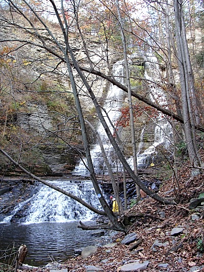
 Roger Hopkins at the foot of Emilie Jonas Falls
"Jack is a big believer in a sense of place," Hopkins says. "That's why you live here. It's not because you live in a house with a roof and four walls. It's because you live in a place that appeals to you."
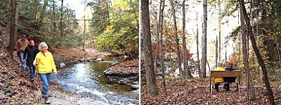
The nature path is certainly appealing. It consists of a fragile, two-winged switchback down the steep gorge into the Shurgar Glen Unique Natural Area, along Gulf Stream to the falls. Hopkins loaned me hiking spikes and a walking stick, which, it turned out, I really needed. The whole thing is only a half mile round trip, but you get a workout going down and more-so going up, because the first wing of the V-shaped trail is quite steep. You have to pay attention, not an easy task because the views into the gorge are breathtaking and it is easy to be distracted by them.
 The first arm of the V-shaped trail is very steep, and the second is slippery. But with good shoes, hiking spikes and some care even an avid indoorsman like me can make it all the way to the falls
The brochure warns, "This is a difficult trail on very steep terrain with poor footing. The rocks near the waterfall may be extremely slippery. Do not attempt this trail if you are unsure of your ability or your footwear. For your safety and to prevent trail erosion, do not use this trail when it is closed or when it is wet."
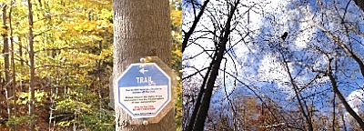
The brochure isn't kidding. I took it slowly and Roger was generous in pacing himself to my absence of speed. The trail is clearly marked with signs that are easy to see, but small and unobtrusive. 'Historical items' -- an old horse-drawn plow and other items -- lie rusting at one point. In software parlance, the plow is a feature, not a bug. We continued down a steep path that has rock steps carved out in places, and is simply a narrow swatch along the steep hill in others.
The committee has been instrumental in advocating that as development in the town takes place that walking trails be part of the plan. The committee's grand plan is to connect major points within the township -- the schools, the town center, the mall -- to each other so children and adults can safely walk between the points.
"We want trails to be part of the development plan if land is developed," Hopkins says. "In the short term if people can walk on it -- it doesn't have to be improved. It doesn't need much maintenance. It doesn't have to be plowed in the winter. But people can see where they live."
So trails can be immediate if landowners are agreeable. And part of the enticement is that they can be moved, if necessary, when development comes.
"You can see the idea of being able to get from the town center to Asbury and Triphammer," Hopkins says, pointing to a conceptual map showing trails winding along the whole township. "We've got some work to do to make that happen. Then we're into Jack's land almost to Burdick Hill Road. Then we've got a few other landowners we need to enlist, particularly for revokable easements, flexible easements. If the land is developed the trail can be flexed."
The other piece is pathways that don't necessarily go somewhere, but are there for the enjoyment of nature. That's where the Jonas Falls trail comes in. Pathways Committee worked on making that happen for about a year and a half. A good part of that time was spent negotiating with the landowners.
The committee agreed to take care of the trail, to police it, put up proper signage and deal with any problems such as trespassing on land off the marked path or other unwanted activities. Once the legalities were agreed to it was time to build the trail.
Hopkins started the actual work in June with the help three college students and volunteers including his wife Ruth, Ted Laux, Donald Jonas and Kathy Conlon Payne. Hopkins built a Leopold bench, the style of which, incidentally, is named for Village of Lansing trustee Lynn Leopold's father-in-law Aldo. The bench was carried down the steep path to the perfect spot for viewing the falls. They worked on the kiosk together, and placed a bat box on a tree near the kiosk that holds a guest book that hikers are encouraged to sign. Hopkins laid out the trail and designed and made the marker signs. By September it was open to the public.
When we reached the bottom of the first arm of the V the going got easier. We soon reached the edge of Gulf Creek, and as we walked toward the falls the path mostly flattened out, though there are some spots where you need to hold onto a branch or a root to swing yourself around an obstacle. As you walk along a terraced area of the creek you soon approach a split in the path. Go to the right and you find yourself in a viewing area where you may sit on the Leopold bench within a circular space defined by an attractive stone border. The left-most path takes you to the bottom of the falls itself.
 Emilie JonasThe Falls were named for Emilie Jonas. Born in 1877 in Nebraska, she married Tomas Jonas before moving east to Lansing. They raised four daughters and one son on their prosperous farm here. The falls was part of their property, and a favorite family part of the Jonas farm that she enjoyed until her death in 1940. Their descendants continue to own and enjoy it, and now to share it with the public.
When we arrived at the falls the perfect amount of water was flowing over in two main streams. Foliage hanging below justs in the rock made the cliff seem as if it had been decorated by a celestial hand, and the water flowed into a pool before working its way down the terraced rock surface in Gulf Creek. It had rained that morning, but not so much that the trail was impassable. We lingered by the falls before starting the steep hike back.
The Lansing Pathways Committee is a volunteer citizen committee appointed by the Lansing Town Board. Taxpayer money is not used for public trails in the town. Instead, the committee raises money, materials and labor from volunteers and donors with an interest in seeing walking paths in the town.
Now is the perfect time to walk the path, while there is still some fall foliage and before hunting season goes into full swing. During that season, of course, it is wise to wear a bright color -- orange if possible. Even for an avid indoorsman like myself the hike was well worth it. It was so great that I might even do it again some day!
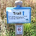
To get there turn west on the northern of the two East Shore Circle turnoffs off of East Shore Drive (Route 34). Look to the right for a quite small sign marking the beginning of the trail. You have to pay attention or you will miss it. Or if you put 94 East Shore Circle into your GPS it will take you there. Another small sign tells you whether the trail is open or closed. And don't forget to open the bat box and sign the guest book on your way out.
v9i41