- By Dan Veaner
- News
 Print
Print  Ludlowville Bridge
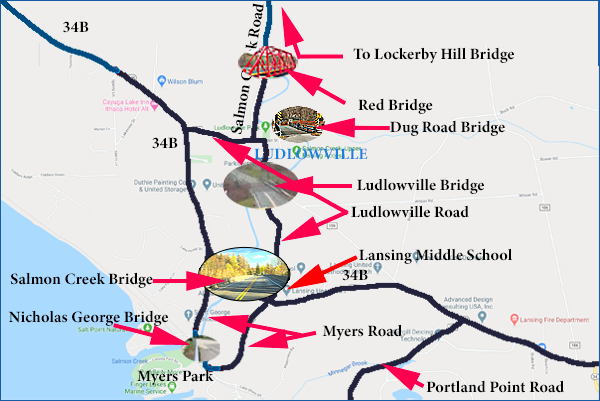
Here's a riddle. A small hamlet has three roads leading into or out of it. One will be closed for bridge repair. Another leads to a State Road, which also has a bridge that will be closed for repair. The third has a newly repaired one-lane bridge that, after taking you far out of your way leads to a road with a damaged bridge that takes you to another long road that gets you to the state road with that other closed bridge. How do you get out?
For residents of Ludlowville that's no joke. It is likely to become a reality later this year. But the answer to the riddle isn't as bleak or as simple as it may seem. The Salmon Creek Bridge on Route 34B, traversing the gorge behind Lansing Middle School, can be bypassed using Myers Road. So it won't be as inconvenient as it could have been for Ludlowvilleans to get to South Lansing or Ithaca. According to Lansing Town Supervisor the work on the Ludlowville and Salmon Creek bridges may overlap for about two weeks -- or it may not. One thing is sure. There will be well over a year of disrupted traffic in South Lansing.
LaVigne updated Lansingites this week on the various bridges and projected work dates. The Town doesn't actually own any bridges. The ones in Lansing belong either to New York State or Tompkins County. Ludlowville Bridge, Red Bridge, Lockerby Hill Bridge are county bridges. The Salmon Creek Bridge on Route 34B (a state road) belongs to New York State.
 Lansing Bridges
Work on the Ludlowville Bridge (which spans Salmon Creek on the north-south portion of Ludlowville Road near Maple Ave) is slated to begin next Tuesday, July 28th. The Tompkins County Highway Department estimates work will be completed by December 15th of this year. That cuts off access to the southern portion of Ludlowville Road that passes Lansing Middle School to connect with 34B immediately east of the Salmon Creek Bridge.
Bids for the Salmon Creek bridge will be opened September 10th, and the New York State Department of Transportation (NYSDOT) hopes for a starting date of November 20 of this year. This is not a simple repair job, where half the bridge could remain open while work is done on the other half. In 2015 NYSDOT closed the bridge for repairs when their inspectors found problems with steel underneath the bridge deck. Even after temporary repairs were completed and the bridge reopened, NYSDOT began planning for replacement of the bridge.
 Salmon Creek Bridge
In 2017 NYSDOT officials came to Lansing to explain that the now 90 year-old-bridge, had deteriorated to the point where it needed to be torn down and replaced. This $19,500,000 project, paid for with state and federal money, was originally expected to begin in the Spring of last year, and an aggressive schedule called for it to be completed before the beginning of this year.
Delays in funding pushed the construction to this year, and fear that the deterioration had made the bridge unsafe led NYSDOT to make it a one-lane bridge last year until more temporary repairs could be effected. The bridge is finally on the active schedule. NYSDOT anticipates work will begin in mid-November this year, and actual demolition of the bridge will take place during the last week of November through the first week of March in 2021. Completion of the new bridge is expected in the summer of 2022.
NYSDOT describes the project: "This project calls for the full replacement of this three span steel arch bridge. Built in 1930, the bridge handles traffic into and out of Ithaca. Nearby are several schools, farm fields, a county park and marina on Cayuga Lake as well as the Cargill Salt mine and a quarry. Daily traffic is over 7700 vehicles."
The new bridge will replace the current 11 foot east and westbound lanes and narrow 3.7 foot shoulders with standard 12 foot lanes and 8 foot shoulders, two feet wider than standard shoulders. The current arch-designed bridge will be replaced with by a design that uses angled girders to distribute the weight load from the deck that will be rated for the maximum legal load for trucks. A NYSDOT official said the new design will not have as many welds as the existing bridge, and it is expected to last at least 75 years.
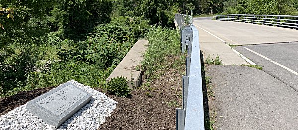
 Nicholas George Bridge on Myers Road
While the bridge is being replaced traffic will be rerouted to Myers Road, which loops south from 34B on the east side of Salmon Creek Bridge to Myers Park and back to 34B on the west side of Salmon Creek Bridge. Myers Road also has a bridge, the Nicholas George Bridge, that spans Salmon Creek. In 2017 NYSDOT officials said truck traffic would be routed north on 34B where it meets Auburn Road (State Route 34), while passenger cars and local delivery vehicles only would be routed onto Myers Road. But residents there were wary of the plan because of traffic issues including speeding that already existed there. Town officials immediately responded with a plan to reduce speeding, at least on the portion leading from Lansing Middle School to Myers Park.
The shoulders were made wider with gravel, radar signs and patrols of the road were increased to keep drivers to the 25mph speed limit and to make the road safer for pedestrians.
"We all know that Myers Road is going to be the unofficial detour," LaVigne said at that time. "Except for large trucks -- those detours will be posted on state roads, so they'll have to go on Route 90 and cut over, up and around. So I told people to reach out to me. Sometimes you drive up the road not realizing you're not going 25 miles per hour - you're going 45 because you're pulling a boat behind you. I've done that myself. It's easy to do."
Speeding on Myers Road remains a concern, especially during the bridge closing, because already frustrated commuters are likely to speed.
 Red Bridge
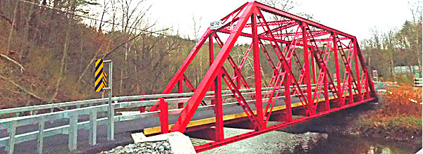
That's two of the three roads that lead into Ludlowville. The third is Salmon Creek Road, which leads north out of the hamlet. The historic one-lane Red Bridge connects Ludlowville with that road. Red Bridge was replaced in 2016 and 2017, finally finished and painted red (after years as a green bridge called 'Red Bridge') and dedicated at the end of 2017. When it became clear that the two other bridges might be closed at the same time Lansing Fire Chief Scott Purcell obtained permission from the Tompkins County Highway Department to use the bridge to bring emergency vehicles into the hamlet, if needed. But he remained concerned that response times would be increased during the closings.
"I bring you these concerns to make you aware of the issues Lansing Fire Department is having," Purcell wrote to the Town Board. "I am aware that the Town does not oversee or maintain any of the bridges in Lansing. If that were the case we would not be having this conversation because the problems would have been addressed a long time ago and would have been taken care of. What I am asking is that the Town Board use whatever power it has to reach out to other government officials such as members of the State Assembly and State Senate to find the funding to fix these bridges and make them capable of supporting large fire apparatus again. I know there will not be an overnight solution to the problem, but it needs to be addressed and a plan put in motion to fix this problem before there is a large loss of property, or, even worse, the loss of human life."
 Dug Road Bridge
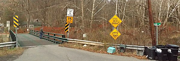
Purcell also brought attention to the Dug Road bridge, which has had a reduced weight limit as well. Dug Road is a small residential Ludlowville street, separated from the bulk of the hamlet by Salmon Creek. Originally limited to 15 tons, it is now capped at 6 tons, which means it is unable to sustain the weight of emergency vehicles. This bridge does not appear to be on the radar for upgrading.
Yet another bridge complicates routing via Salmon Creek Road. The best way to reach 34B from Salmon Creek Road in the north-most portion of Lansing is via Lockerby Hill Road. But the bridge at the bottom of that road where it meets Salmon Creek Road has also deteriorated to the point where NYSDOT has made it a one-lane bridge, with that lane being in the middle of what is actually a two lane bridge. LaVigne says he was told that will continue while NYSDOT evaluates critical structural elements, which are encased in concrete. No one is predicting what will happen to that bridge until the evaluation is complete.
If you have noticed signs on 34B warning of road work near Portland Point Road (which leads to the Cargill salt mine as well as Portland point, they have been placed there because the road will be closed this weekend, today (July 24th) through 6am Monday morning for maintenance on a box culvert.
v16i30


